
River Reflections: Shifting Sands And Stressed Lives
Floods. Landslides. Environmental degradation. Pollution. It all adds up to a story of disappearing land, displaced lives and destroyed livelihoods along the Brahmaputra
|9 July, 2022
THE Brahmaputra has always been a great sediment carrier–after the Yangtze Kiang in China, it carries more silt and sand than any other river on earth. Thus the alluvial fans of the Brahmaputra, visible through satellite imagery, reach into the Bay of Bengal and build the natural land area of Bangladesh.
But in the past years, the river has become broader and shallower, and its large companions (I don’t like to call them tributaries) are also shrinking in depth, volume and width in the winters.
In 2021 the rains came late, and so did the high water. This year, the first wave of torrential rain hit much of Assam and other states as early as February, then again in April, and flooding began with the third spell of heavy rain in May.
The unseasonal, untimely flooding forced farmers to rush to their fields, with labourers and members from their communities, to save their rice crops. They brought their harvest onto the roads–the only high land available to them; they dried it on blue tarpaulin sheets and stored it in sacks arrayed on the high ground.
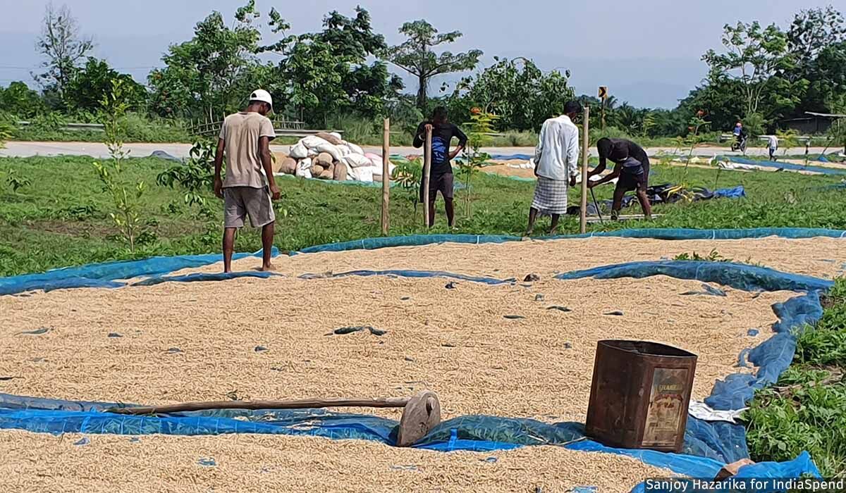
Farmers dry grain on the national highway between Nogaon and Jagiroad in Assam
Thousands were displaced; at least 18 persons died, including several in landslides. This drew some attention though public and media focus was riveted on the devastation in the Dima Hasao district, where a newly minted railway line and railway station were overwhelmed by landslides and floods that toppled trains, uprooted tracks, and severed connections with the rest of the country.
The Guwahati High Court reportedly asked the Northeast Frontier Railway, as part of a Public Interest Litigation hearing, why recommendations from a report of the Commissioner of Railway Safety in 2015 were not implemented while constructing the railway line. It is alleged that the new track was poorly designed and built in a hurry, with engineers and contractors not paying due attention to the local geological structure. This resulted in the felling of thousands of trees, whose roots are what bind the soil together, and the indiscriminate gouging of hills, which weakened the slopes and created the conditions for destructive landslides. A top state official says it will take at least six months to get the system in the district back to a semblance of normalcy.
Inter-connected issues resonate elsewhere. In Dibrugarh and Lakhimpur, senior officials blame increased sedimentation in the river on indiscriminate deforestation in the hills of Arunachal Pradesh directly above, which sends rocks and soil cascading down to the river.
This is the fourth and final part of our series, Reflections From A River. Here is the first part, the second part, and the third part of the journeys on the Brahmaputra.
*****
IN initialbreathless reporting about floods and their aftermath, especially in ‘mainland India’ and the metro media, there seems to be an established pattern. A burst of stories hits headlines in print, television and social media about the ‘unprecedented’ downpour, the scale of flooding, the hundreds of thousands of displaced persons, devastation to livestock, property and government infrastructure as well as the notional loss to the economy. Leaders rush to observe the damage from the air (every prime minister has done this in the past 75 years). As the floods recede (there can be three waves of floods), these stories peter out and the media loses interest–until the next year, the next flood.
But what happens to the sapori dwellers, to their lives and their livelihoods, once the floodwaters recede? How many think of that and write or broadcast about the painful return home? Many return to find that the land on which they had built their lives has been either obliterated or, in many instances, shifted downstream, or a new island has grown upstream. This often means the following: rebuilding homes, re-growing farms, re-fashioning livelihoods, not once in a lifetime but two and sometimes three times in a single year.
The challenge of flooding in the Brahmaputra valley is exacerbated by the fact that the great river and its companions have turned broader, but shallower. The question is how? And why?
Until recently, there was no trans-Arunachal highway connecting several large valleys in the sprawling state of Arunachal Pradesh, which borders Tibet. Commercial and passenger vehicles were forced to make long, expensive detours into Assam before moving back into Arunachal. Road building is thus regarded as essential for both economic and national security reasons. Yet, the cutting of hill slopes and deforestation that this necessitates means that much of the debris land in the valleys below. It is not clear how much of this is retrieved, or transported elsewhere for construction purposes.
As a result, the carrying capacity of the Brahmaputra and other rivers is diminished by the increasing load of mud and rock and debris, forcing the rivers to dump the silt as they travel onwards, reducing in depth while broadening in girth.
*****
CHANGING weather patterns are creating new challenges for farmers, businesses and administrators. At Guwalbari, a village of 900 members of the Mishing tribal community in Lakhimpur district, Pushpo Pegu gazed at a field of green paddy and rued the loss of last summer’s crop. “The rains came too late last year,” said Pegu, a health worker in the village, gesturing at his neighbour’s shimmering green patch of paddy. “Things are so uncertain; we don’t know when to plant and what to plant, because the weather could change anytime and bring rain.”
At Guwalbari, which as its name suggests is a place for dairy farming, each home is a light structure of flexible but tough bamboo lattice topped with straw or tin roofs and standing on strong bamboo stilts. It’s an indigenous design, perfected over the centuries by this community in Upper Assam to protect them from both floods and, in earlier times, from wild animals.
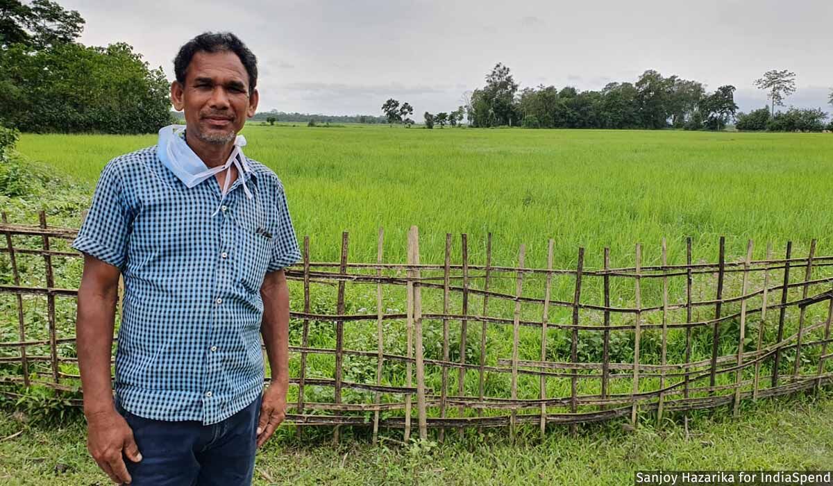
Pushpo Pegu, near his neighbour’s glowing rice fields. The rains were delayed last year, and came early this year, erratic weather patterns that impact lives and livelihoods.
We climb to Pegu’s chang ghar, as such homes are called, via a log with small steps notched into it. Inside, it is cool, dark and airy–a refreshing change to the long boat ride, a trek through fields and the village, and an animated discussion with a group of village women and elders.
We sit on little murhas made from plastic sacking stitched together and placed on the bamboo floor. The seats are comfortable, and the recycling is impressive. The womenfolk serve us the cooling sai apong, freshly brewed rice beer, in broad brass bowls. The apong is followed by bowls of pork in curried pumpkin, laced with garlic and black pepper, a unique and delicious combination.
These are pristine spaces of bewitching beauty, still largely untouched by the scarring power of unplanned development and infrastructure. There are opportunities here–such as for off-circuit tourism for backpackers, environmentalists and researchers–and in other spaces elsewhere, even as the changing weather patterns provoked by climate change create new vulnerabilities and challenges.
*****
I TRAVELLED to the Dibru Saikhowa National Park, which sprawls across parts of Dibrugarh and Tinsukia districts and is bordered by the Brahmaputra and Lohit Rivers to the north and the Dibru to the south. We didn’t spot any wildlife, as we were travelling during daylight hours. The days, barring dawn and dusk, are too bright and hot for most species–but we did visit a village and forest camp located in the park.
The issues here were the same as in other districts: erosion is eating away at the land, livelihoods and incomes. “We are getting 5 kg of free rice regularly, that’s a big help,” said Nandanath Regon, a wizened, bare-chested Mishing who lives in the forest village of Laika Pomua.
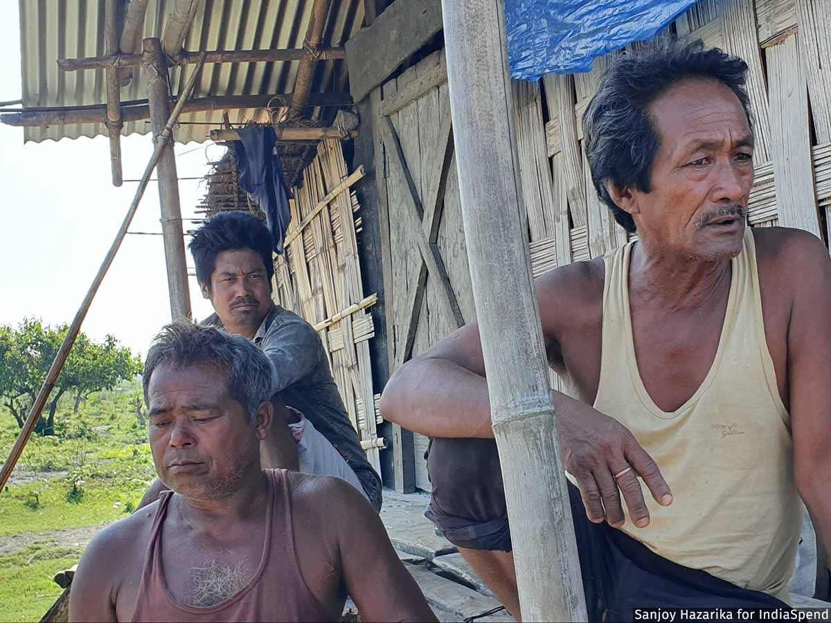
Villagers at Laika Pomua in the Dibru Saikhowa National Park. Their village is threatened by erosion.
The 60-year-old is among the Mishing community who had moved here some years back during a large flood, and from the high ground he can see neighbouring houses in retreat from the eroding river, barely a kilometre away. “We will all have to go at some point even if we don’t want to,” said Regon as he surveyed his banana grove, and the little huts where pigs with their brood were snoring. Chicks scurried about, hustled by a mother hen. The family brought out two beautifully crafted chairs of cane kept for visitors, and served red tea in paper cups. It could have been idyllic, but for the looming menace of the river eating away at the land and creeping ever closer.
Free rice is important, said Lakhinath Ngatey, as he stood by Regon, but “more important now is land where we can settle. The young people are moving out as there is no work here for them.” The elders here say that the youth of the village are heading out to Guwahati and beyond.
In Tinsukia, I visited the site of a spectacular blowout of an oil well at Baghjan, near Natun Rongagor village, close to an ecologically sensitive area that includes Maguri Motapung Beel, an internationally renowned bird habitat. The blowout, which took 110 days to cap, was one of India’s worst oil disasters and, besides the pollution it spewed into the air, it killed three and displaced nearly 9,000 persons, many of whom stayed in relief camps during the period.
An inquiry report by Assam’s Forest Department initially estimated the economic loss at Rs 25,000 crore and a biodiversity loss of 55%, reported East Mojo. Oil India Limited (OIL), a unit of the Indian Oil Corporation, paid Rs 147.92 crore in compensation and relief to over 600 families who were directly impacted.
Anupam Chakravartty, a reporter with the online news site East Mojo, quoted a Supreme Court-mandated inquiry to report that nearly 4 sq km of land impacted by the upsurge was damaged beyond redemption. The report said that the concentration of highly carcinogenic Poly-Aromatic Hydrocarbons (PAHs) in water, soil and sediments of Lohit, Dibru and Maguri-Motapung were significantly higher than those reported in other Indian and global studies on similar accidents. PAHs are highly carcinogenic chemical compounds produced during the incomplete combustion while burning coal, crude oil and gasoline. These compounds can easily bind with organic material leading to large-scale biological degradation of ecosystems impacted by oil spills.
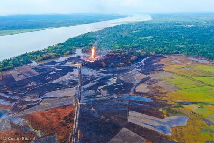
Blowout of an oil well at Baghjan.
More than 75 hectares had been scorched. Large swathes of rich paddy fields were covered with oil, muck and residue; trees and vegetation for kilometres around were burned and blackened; countless birds, both migratory and local, were roasted alive while a dead river dolphin was washed up.
Migratory birds are returning but in fewer numbers, says Joynal Abedin, a local environmentalist, wildlife specialist and the owner of an eco-resort by the Dangori river. “The local birds seem to be ok, but the problem is there has been no scientific survey,” says Abedin, a resident of Guijan town with a deep love for the outdoors and a vast knowledge of the ecosystems of the region, which he willingly shares with anyone who wants to understand.
When I visited the region in May this year, the green sheen was back on the leaves of trees, fields and bushes. The streams appeared clear and clean. I was told, though, that residues from the blowout were affecting replanting efforts, despite the clean-up. Abedin, a large, intense man, says there are still major problems caused by the ecological disaster. Some fish species have disappeared, and silting is also a problem here. Excess silt and sand are harming Maguri beel, the wetland. He rattles off the figures of creatures at risk: “Ninety-eight species of birds, 120 species of fish and 100 species of butterflies.”
Chakravarty, the reporter for East Mojo, wrote about failed efforts by farmers to grow crops. The vegetables would turn yellow, wither and die. In one striking case, he cited the experience of Ritu Chandra Moran who was planting tubers. He had dug barely “a few inches” when an “oil slick oozed out of the hole meant for the stout Kosu (taro)”.
*****
A MAJOR challenge before the many rivers and their dependent communities lies in the downstream impact of upstream interventions such as dams. The giant Subansiri project in Arunachal Pradesh, billed as the largest hydroelectric project in India, is finally approaching completion and is supposed to go on stream in 2023. It was initially scheduled to be finished in 2018, but landslides and other problems required extensive redesign. Local opposition and protests also slowed the process of building.
The Ranganadi dam, on the river of that name in Arunachal, has been functioning since 2001. I travelled to the river from Guijan, in Tinsukia district, and found that it had shrunk to a trickle. As I watched from the bank, a woman walked across much of the empty riverbed with ease while, in the distance, the ubiquitous excavators tossed mud and sand onto a truck waiting on the river bed. Mining is to be done only based on the guidelines put out by the government, with no-mining zones to protect the river. Indiscriminate mining damages the river system, accelerates erosion, causes local habitat disruptions including harming endemic fish and other river-dependent species, harming fishing livelihoods, and adversely impacts access to ground water for neighbouring communities.
I’m not getting into the big dams versus environment debate here–that is complex, and nuanced, and cannot be contained in any single article. But I will, for now, say that all eyes are on the mega dam on the Subansiri. Engineers and officials say that a lot of protective work has been done along the river banks. What we know is how the dam, and therefore the changed flow of the river, will impact downstream communities.
We know this because we have the example of the smaller Ranganadi dam–villages downstream of it are struggling with endemic erosion, damaged fields, falling crop yields, dropping fish catch, and displacement. Keep in mind that the Subansiri is much larger–and therefore the downstream consequences could be much more substantial. But bearing witness will have to wait for a year.
Sumit Sattawan, the young Deputy Commissioner of Lakhimpur, spoke wisely of an issue I had not considered earlier, but which is deeply connected to the larger concerns of changing weather patterns and climate change. He pointed out that communities like the Mishing are accustomed to, and welcome, an abundance of water.
“What populations may have to get cope with is a scarcity of water, they are completely unused to this,” said Sattawan, as we sat in the Lakhimpur Circuit House. He saw this as a key challenge “for all of us”, to help train people and equip them to manage the transition.
*****
THE spells of wet weather and storms underline the relentless challenges rural and urban communities in the region face. Near the town of Jagiroad in Morigaon district, I see villagers on the highway, where they’ve spread out the grain they’ve rescued from their fields during the sudden flood. They stir the paddy with their feet, hoping it will dry as the sun beats down. No government official has visited the area to assess damage, one farmer tells me.
Over 150 km away, a boat builder speaks of the changes to the river: “One thing I can tell you,” says Ismail Sheik, in the small town of Nagarbera. “In the past five to 10 years, the river has become shallower; navigation is difficult and we don’t know why that is–they say there are dams being built in China which are making this happen.” The roads and lanes here are messy after days of incessant rain. But the river here, flowing through the sprawling district of Kamrup, is strikingly handsome, as is the countryside.
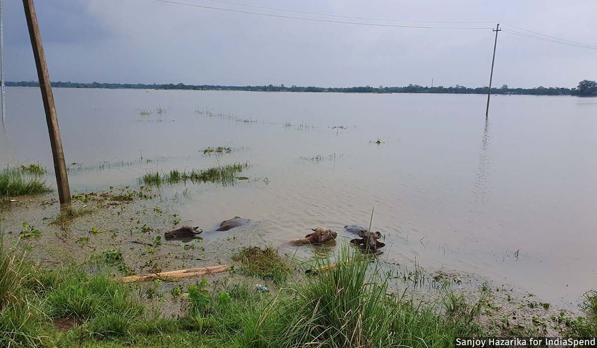
Beauty is balanced by tragedy. The paddy fields on either side of a superb rural road are deep under water. A group of water buffaloes, their heads sticking out, wallow in the silty water. They seem to be the only ones enjoying themselves.
It needs to be emphasised that it is not just one river, or even a network of rivers, that is at stake–it is the entire river basin, which carries the waters of no less than 50 rivers and which, in the heavy rains, swell to what the river scientist Jayanta Bandyopadhyay called 5,000 rivers, as seasonal streams and small rivulets burst into life, in a talk he gave some years back.
These many valleys and the basin embrace, without regard for political boundaries, the entire Ganga-Brahmaputra-Meghna basin which includes the sprawling Tibetan Plateau, Assam and other North Eastern states, Bihar, Uttar Pradesh, West Bengal, and Bangladesh.
More than half a billion people call this region home. While this series highlights the unique problems of the Brahmaputra valley, the issues facing the other parts of these gigantic river systems are equally complex.
As we head to Nagarbera, a rare sight unfolds in the distance: A group of six endangered Greater Adjutant Storks, the great bird that is native to Assam and Myanmar, ponderously walk across the landscape, pausing to plunge their long yellow beaks into the water to grab a bite.
This is a far cry from the garbage dumps near Guwahati, where many of this species cluster, risking pollution and death from toxic waste. One documentary speaks of “the grotesque elegance” of the species, which has two-thirds of its worldwide population located in Assam. Locally known as hargila or bone swallower, the stork has a wing span of two and a half metres, and thin long yellow legs. Purnima Devi Barman, a biologist, has mobilised groups of women in rural communities, known as the Hargila Army, to protect and enable the stork to win the battle for survival, to fight superstition and ignorance.
Such struggles and stories of conservation and protection in the face of aggressive growth mark the canvas of the region. Some, like Debojit Chowdhury at Kukurmara, who has spent many years working to protect the highly endangered Gangetic dolphin, feel that the odds are stacked against them. Chowdhury and the members of local communities here are demanding dolphin protection areas on the Kulsi, a tributary of the Brahmaputra, which flows through the town. Sightings of the shy, beloved national–and state–aquatic animal are frequent here. It frolics despite huge pressures from developers, from factories which have sprung up in the neighbourhood, as well as sand extractors, raising questions in my mind, every day: “How much is too much? What is the balance we need to seek? Can the dolphins and the storks survive this onslaught?”
I don’t know the answers.Yet, the challenges before the dolphins or xibu and the Bor Tukola, as the stork is affectionately called in Assam, are just a part of the many struggles facing the Brahmaputra, its valley, its ecosystems and the sentient beings that inhabit both river and land.
*****